Drone topography and LiDAR mapping in Northern Virginia
Drone LiDAR and photogrammetry that deliver bare-earth surfaces, contours, and point clouds ready for your CAD team, including under tree cover where ground crews spend days.
Get a quoteBased in Fauquier County. Mapping sites across Northern and Central Virginia.
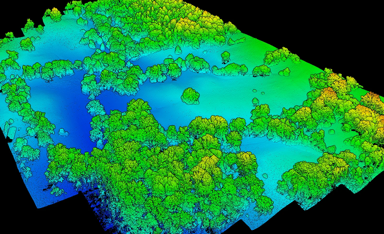 Full point cloud
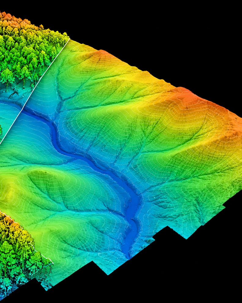 Bare earth
What a drone topographic project delivers
Files built for the engineer who has to design from them, in the coordinate system your drawings already use.
Bare-earth surface
Ground only, with vegetation and structures removed. The basis for grading, drainage, and site design.
Contours
At the interval your designers need, delivered as DXF for CAD.
Classified point cloud
LAS or LAZ, with ground, vegetation, and buildings separated.
Orthomosaic
Georeferenced imagery with a pixel size of a few centimeters, for base maps and existing-conditions plans.
Surface model
The top of everything, including tree heights, structures, and obstructions.
Cross sections and profiles
At whatever stationing your designer specifies, for roads, corridors, and stream channels.
How a drone topographic project runs
The coordinate system and accuracy are settled before anything flies.
- Before the flight
Scope
We confirm the boundary, accuracy, deliverables, and coordinate system in writing, including horizontal datum, vertical datum, and units.
- On site
Control
An RTK base station is tied to known control, and independent checkpoints are set and measured on the ground.
- Flight
Fly
Drone LiDAR for wooded and vegetated ground, photogrammetry for open ground. A 20 to 40 acre site is typically flown in a morning.
- Delivery
Deliver
Surfaces, contours, and point cloud, with an accuracy report measured against the checkpoints.
Who uses drone topography
Civil engineering firms
Field data collection for overflow weeks, without tying up a survey crew for days. Your licensed surveyor reviews and seals the work.
Stream restoration and water resources firms
Bare-earth corridors under full canopy, with cross sections and longitudinal profiles for design.
Developers and land planners
Early topography for feasibility, drainage, and slope analysis before design starts.
Land and conservation monitoring
The same drone LiDAR and thermal tools, pointed at large properties and conservation land.

Conservation easement monitoring
Repeatable annual imagery and change detection across an easement portfolio, as a documented supplement to on-site monitoring.
Forest inventory and canopy height
LiDAR canopy height models and tree counts, plus the bare ground beneath them.
Wildlife and herd counts
Winter thermal surveys that find animals by body heat, including beneath tree cover.
Large-property records
Fences, roads, ponds, trails, and timber mapped and dated for owners and land managers.
Drone LiDAR sees the ground under trees
Photogrammetry only sees the surface it photographs, so under canopy it maps treetops. Drone LiDAR records multiple returns from each laser pulse, capturing bare ground beneath the canopy.
That makes it the right tool for stream valleys, wooded lots, and vegetated slopes, where a ground crew would otherwise spend days.
Your coordinate system, confirmed in writing
We deliver in Virginia State Plane North or South, NAD83(2011), with NAVD88 elevations, or your project's local system. Units are confirmed as US survey feet, international feet, or meters before we fly, since mixing them up shifts data by more than 20 feet.
We collect data; we don't practice land surveying. Work that needs a professional seal is performed under a licensed Virginia surveyor in responsible charge.
Questions about drone topography
How accurate is drone topographic mapping?
With RTK positioning and ground checkpoints, accuracy on open, hard ground is typically within 2 to 5 cm. Under vegetation it depends on how much ground the LiDAR reaches. Every report states the accuracy measured against checkpoints held out of processing.
Does drone mapping replace a land survey?
No. Drone mapping collects topographic data efficiently, but it isn't a boundary survey. Where a sealed survey is needed, we work under a licensed Virginia surveyor in responsible charge, or deliver the data to yours.
How much does drone topographic mapping cost?
Most sites of 20 to 40 acres run $1,200 to $4,000, depending on size, vegetation, and deliverables. LiDAR under heavy canopy and cross-section work sit at the higher end.
When should I use drone LiDAR instead of photogrammetry?
Use drone LiDAR wherever ground is covered by trees or dense vegetation, or where you need true bare earth. Photogrammetry is faster and less expensive on open ground, like cleared sites and bare earthwork.
What coordinate systems do you deliver in?
Virginia State Plane North or South on NAD83(2011), with NAVD88 elevations through the current geoid model, in US survey feet unless you specify otherwise. We also deliver in local project systems.
How many acres can you map in a day?
A 20 to 40 acre site is typically flown in a morning, and a few hundred acres can be collected in a single day in good conditions. Processing time grows with point density and deliverables.
What file formats do you deliver?
LAS or LAZ point clouds, GeoTIFF surfaces and orthomosaics, DXF contours, and PDF accuracy reports. Tell us what your CAD team opens and we'll match it.
Can you work as a subcontractor to our survey department?
Yes. That's most of our engineering work. We collect the data to your specifications, and your licensed surveyor takes responsible charge and seals the deliverable.
Mapping projects we serve
We map sites across Northern and Central Virginia, including Loudoun, Prince William, Fairfax, Fauquier, Stafford, Culpeper, and Spotsylvania counties, from development sites in Gainesville and Warrenton to stream corridors and wooded parcels across the Piedmont.
Get a quote for your site
Send the site boundary or address, rough acreage, how wooded it is, and the deliverables you need. We'll reply with a flight plan and a price.
Get a quote- spencer@sandtair.com
- Phone
- (805) 814-5803
- Based in
- Broad Run, Virginia