Drone property inspection and storm documentation in Northern Virginia
A dated, mapped record of every roof, wall, and parking lot on your property, made before anything happens. When a storm does hit, your claim rests on proof instead of memory.
Start your baseline recordFor commercial property owners, property managers, HOAs, and the agents and adjusters who work with them.
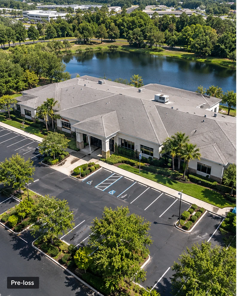 Baseline
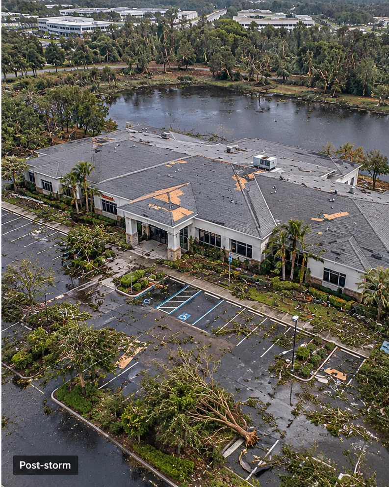 After the storm
Why document a property before you need to
Most claim disputes come down to one question: what did it look like before?
"It was already like that."
Without a record from before the storm, damage can be written off as a pre-existing condition or ordinary wear and tear.
"When did this happen?"
Dated, located photos show when damage appeared, not just that it exists.
"Show us the whole roof."
A site visit sees what fits on a ladder. You'll have every square foot, from above, already on file.
What your drone property record looks like
Every visit produces a report you can forward straight to your roofer, agent, or adjuster.
- 1Displaced flashing at rooftop unitNortheast unit. Photo 0142, zoom close-up, with date, time, and GPS location.
- 2Membrane seam liftingCenter ridge, 6 ft run. Photos 0151 to 0153.
- 3Gutter separated from fasciaSoutheast corner. New since last record.
- 4Debris at roof drainSouthwest drain. Photo 0168.
Roof plan map from a drone orthomosaic, with every finding numbered.
Every elevation photographed from consistent angles, visit after visit.
Close-ups of roofs, flashing, gutters, and rooftop equipment from the zoom camera.
Change report comparing each visit against your last record.
Date, time, and GPS location embedded in every original photo.
A private link to your property's records, so nothing gets lost in email.
When we document your property
- First visit
Baseline record
A complete record of the property as it stands today: roofs, walls, paving, drainage, and rooftop equipment.
- Every year
Annual record
Re-flown from the same viewpoints, so year-over-year change is obvious at a glance.
- After every storm
Post-storm record
Priority scheduling once it's safe to fly, compared directly against your baseline.
Drone property documentation pricing
Priced by the size of your property. The annual program gives you a full year of coverage for not much more than a one-time record.
| Tier | Roof area | Site | Typical property | Annual program | One-time record |
|---|---|---|---|---|---|
| Small | Up to 25,000 sq ft | Up to 3 acres | Church, single retail building, small office | $5,000 | $3,000 |
| Medium | 25,000–100,000 sq ft | Up to 10 acres | Strip center, school, mid-size office | $10,000 | $7,000 |
| Large | 100,000–250,000 sq ft | Up to 25 acres | Shopping center, multi-building campus | $15,000 | $10,000 |
| Campus | Over 250,000 sq ft, or multiple sites | Larger | Distribution center, industrial park | From $20,000 | From $15,000 |
Prices are per site, per year for the annual program. Roof area is the total across all buildings on one site.
Annual program
- Annual site documentationAt least one complete record of the property every year.
- Up to 12 post-storm visitsPriority scheduling after hail, wind, snow, or any event you call in.
- Change reportsWhat's different since your last record, after every visit.
- Original files on requestUnaltered photos with date, time, and GPS location intact.
- Records kept for as long as you're a clientAnd a complete copy delivered to you if you ever leave.
One-time record
- A complete record of the propertyRoofs, walls, paving, drainage, and rooftop equipment.
- Report with numbered findingsRoof plan map and dated photos for every finding.
- Original files deliveredEvery photo with date, time, and GPS location intact.
- Scheduled as availability allowsAfter annual program clients.
- Post-storm visits at the same rateEach call-out is billed at your tier's one-time price.
Three or more properties: 10% off the annual program. Low-slope roof? Add a drone thermal roof moisture survey to any visit.
Records that hold up
Every original photo keeps its date, time, and GPS location, and we archive the originals unaltered. That's what turns pictures into a record someone can rely on later.
Each property gets a private link to its full history, available whenever you need it.
What we document, and what we don't
We record the condition of your property and flag visible changes between visits.
We don't determine the cause of damage, its value, or what your policy covers, and we don't negotiate claims. Those decisions belong to your insurer, adjuster, and roofer, and our record gives them the evidence to make them.
For insurance agents and adjusters
If your clients own commercial property, a baseline record on file makes every future claim cleaner. We work alongside agents, brokers, and independent and public adjusters, and deliver files in whatever format your process needs.
Talk to us about your clientsQuestions about drone property documentation
What is pre-loss documentation?
A dated, located record of a property's condition made before any damage occurs. If a storm or accident later causes damage, the record shows what the roof, walls, and grounds looked like beforehand, so the claim can't be dismissed as a pre-existing condition.
Will my insurance company accept drone documentation?
Insurers and adjusters routinely use drone imagery, and every photo we deliver carries its original date, time, and GPS location. How a claim is decided is up to your insurer; our job is making sure the record exists and holds up.
How fast can you document after a storm?
Annual program clients get priority scheduling after a storm, as soon as weather and FAA rules allow safe flight, and every visit is compared against their baseline. One-time clients are scheduled after program clients.
What counts as a post-storm visit?
Any visit you request after a weather event, including hail, high wind, heavy snow, or a fallen tree. The annual program includes up to 12 a year; for one-time clients, each visit is billed at their tier's one-time price.
Can I get a one-time record instead of the annual program?
Yes. One-time records run $3,000 to $15,000 and up depending on property size, and are scheduled as availability allows. Post-storm visits for one-time clients are billed at the same rate as the record.
How is the price determined?
By the total roof area of all buildings on one site, with an acreage limit for each tier. Properties over 250,000 square feet of roof, or programs covering several sites, are quoted individually.
Do you inspect for damage, or just photograph?
We document condition and flag visible changes in a change report after every visit. We don't determine the cause of damage, its value, or what your policy covers. Your roofer, adjuster, or insurer makes those calls with our record in hand.
Can a drone see hail damage on a roof?
Our zoom camera captures close detail on shingles, membranes, flashing, and rooftop equipment from a safe distance. Confirming hail damage usually still involves a roofer's hands-on check, and our record shows them exactly where to look.
How long do you keep our records?
For as long as you're on the annual program, and you can request the original, unaltered files at any time. If you ever leave, we deliver a complete copy of every record, so your property's history stays with you.
Do you fly over occupied buildings?
We plan every flight to avoid flying over people, follow FAA rules, and coordinate with your tenants or staff when a site is occupied.
Properties we document
We document commercial buildings, industrial sites, retail centers, churches, schools, and HOA common areas across Northern Virginia, including Loudoun, Prince William, Fairfax, Fauquier, Stafford, Culpeper, and Spotsylvania counties.
Get your property on file
Send the property address, building count, and approximate roof area. We'll schedule your baseline record.
Start your baseline record- spencer@sandtair.com
- Phone
- (805) 814-5803
- Based in
- Broad Run, Virginia